Popular environmental complaint·PROFEPA folio 0920121·November 12, 2026Under review
Case file · Cuemanco, Xochimilco
Complaint over the destruction of a chinampa for a parking lot and a tourist pier
A riverside chinampa on the Antiguo Canal de Cuemanco stopped being farmland; it lost its soil, its trees and its water edge to operate as a car park and a tourist pier. All of it inside the Xochimilco Protected Natural Area. The benefit goes to a few tour companies flagged for other offenses, such as the use of gasoline engines and other practices harmful to the wetland.
Authority
PROFEPA
Subject
Chinampa, soil and canal edge
Channel
Popular complaint
Photo 1. The access gate: tours, food offerings and events operating on the plot are all advertised on one frontage.
2014–2026
Satellite series of the plot
>20 m
Shoreline strip intervened (preliminary)
5 marcas
Operating from a single gate
2,522 ha
Protected Area surface
I. Facts
What the complaint states, point by point
The filing describes observable facts and asks the authority to verify them on site. It asserts no crimes and names no one: it holds that a chinampa stops being a chinampa when it is filled, leveled and turned into a parking lot and a pier.
A chinampa is not an empty lot waiting for investment: it is an agroecological infrastructure built over centuries, where soil, water, vegetation and human labor form a single system. When it is filled, leveled and paved, it is not “developed”: it is destroyed.
1
The plot is a riverside chinampa on the edge of the Antiguo Canal de Cuemanco, inside the “Ejidos de Xochimilco and San Gregorio Atlapulco” Protected Area, Ramsar Site 1363 and the World Heritage zone. The 2014 to 2022 images show open farmland and a continuous strip of trees and riparian vegetation.
2
In January 2023 soil was removed in the middle of the plot; by March 2024 the tree mass was gone and the surface leveled. The chinampa stops being farmland and loses its ecological and hydrological function.
3
In March 2025 the surface is occupied by dozens of vehicles: the plot operates as a parking lot. In 2026 the land shows subdivision and topographic work.
4
Where riparian vegetation stood, 2025 and 2026 show a cleared canal edge and mooring structures. The intervened strip preliminarily exceeds 20 linear meters; the measurement must be verified with an official survey.
5
At the gate, several brands offer tours, food, drinks and events. The whole works as one system: arrival by car, parking, transfer to the canal edge, boarding and return.
6
The complaint asks that the whole — plot, parking lot, pier, restaurant and events — be assessed as one project because of its cumulative impacts, and that the soil, riparian vegetation and canal edge be restored.
7
Boats leave from this same access point without proving authorization: no register entry, no SEDEMA permit (Rules 73 and 74), no safety review and no operator identification. These are the point’s pirate boats. The register and inspection records requested from the authority (Annex III, items 09 and 11) will establish how many of the vessels operating here are registered and how many work outside any authorization.
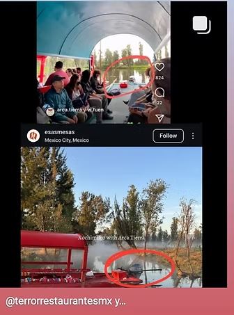
2025 · Close-up of the canal edge: boats and tourist launches moored where the shore was vegetated.2026 · The same stretch a year later: consolidated mooring platforms and roofed boats.
The close-ups are crops of the case-file satellite images, shown in their original orientation so the reader can follow the canal edge.
II. Satellite evidence
Twelve years in eight images
Google Earth captures centered on 19°16’47.9” N, 99°06’11.8” W. Preliminary observations subject to official verification.
January 2014
Open farmland; a continuous strip of trees along the canal.
March 2019
Vegetation cover and a sports-field layout; continuous riparian trees.
April 2020
No relevant changes compared with 2019.
December 2022
Bare-soil areas appear in the middle of the plot.
January 2023
Soil removed in the middle of the plot; the tree mass is still visible.
March 2024
Tree mass removed and surface leveled: the chinampa stops producing.
March 2025
Parking lot in use with dozens of vehicles; the canal edge is now cleared.
January 2026
Land subdivision, topographic work and mooring structures on the edge.
The sequence alone does not prove who carried out the works or their illegality, but it is objective evidence: tree removal, parking and boats appear within two years inside a Protected Natural Area.
III. Legal framework
Five layers of protection over one plot
The plot is not ordinary urban land. A federal reserve, a wetland of international importance, a historic monuments zone and a management program that fixes what may be done and where all overlap on it. A deed replaces none of those layers.
1986
Historic Monuments Zone
DOF decree: Xochimilco, Tláhuac and Milpa Alta
1987
UNESCO World Heritage
Mexico City and Xochimilco (criteria ii–v)
1992
Ejidos de Xochimilco Protected Area
Ecological conservation zone; boundary amended in 2006
2004
Ramsar Site 1363
Wetland of international importance · 2,657 ha
2018
Management Program
Official Gazette, February 26: zoning and activity matrix
Zoning decides the activity, not the investor’s wish
Protection
Preserve ecological components and processes. Compatibility with new commercial development cannot be presumed.
Public Use
Allows recreational activities and services, but subject to conditions, authorizations and limits.
Chinampa and Rain-fed Farmland
Its purpose is to keep chinampa production and landscape: the matrix is stricter for commercial tourism services.
Ecological restoration
Recover ecological functions. A new commercial development cannot be assumed compatible.
Management Program activity matrix (2018)
Activity
CHAT
Public Use
Traditional boats
Allowed
Allowed
Ecotourism
Allowed
Allowed
Traditional tourism
Prohibited
Allowed
Tourism services
Prohibited
Allowed
Crafts and traditional food
Prohibited
Allowed
Low-impact ecotourism infrastructure
Conditional
Conditional
Mass events
Prohibited
Prohibited
Commercial parking and access works
Needs a ruling
Needs a ruling
An indicative summary of pages 123 to 127 of the management program: it authorizes nothing and does not replace the full text. “Traditional boats” and “ecotourism” do not make a corporate fleet or a restaurant lawful: what matters is the real activity, its scale and the infrastructure it requires.
A deed is not a permit
Ownership of the land, if proven, gives rights over the property. It does not by itself grant any of these:
Rights over the canalRights over the waterUse of the federal zoneNavigation spaceMooring rightsEnvironmental authorizationLand-use changeConstruction permit
CONAGUAChannel status, federal zone, occupation and discharges
SEDUVI / AlcaldíaLand use, commercial permit and parking
PAOTLand-use planning and local environmental complaints
INAH / Zona Patrimonio MundialHistoric monuments and heritage values
Protección Civil y sanidadCapacity, gas, fire, food and drink
The rules that apply
Regla 39
Every activity or work inside the Area requires express authorization from SEDEMA under the management program.
Regla 108
Prohibits land-use change and any use outside the Area’s regime, as well as events with sound, light or vibration affecting flora, fauna, soil or water.
Art. 138 · Ley Ambiental CDMX
Activities inside a protected area are subject to the management program and zoning; anything harming biodiversity or interrupting the hydrological system is prohibited.
Art. 28 · LGEEPA
Assessment must consider the entire project and its direct, indirect, cumulative and synergistic impacts.
IV. Socio-environmental annex
The wetland is not a theme park
The problem is not that people visit Xochimilco or that communities earn from tourism. The problem is a model that increases pressure on a fragile ecosystem, effectively privatizes the benefits of a collective heritage and displaces the decision-making of those who have cared for it.
What it is
Un sistema lacustre y agrícola vivo: canales, chinampas, suelos, agua, vegetación y fauna.
Infraestructura agroecológica construida durante siglos de trabajo chinampero.
Sitio Ramsar y patrimonio mundial: obligaciones de conservación, no una marca turística.
Una red de familias, oficios y conocimientos que mantiene el territorio.
Un lugar donde el límite ecológico manda sobre la expectativa de crecimiento comercial.
What it is not
Un lote disponible esperando una inversión.
Un escenario de consumo: paisaje de fondo para fotos y paquetes turísticos.
Un parque temático con acceso privado y estacionamiento.
Una etiqueta de “ecoturismo” que vuelve lícita cualquier actividad comercial.
Un negocio cuyas ganancias son privadas y cuyos costos quedan en el territorio.
We are not against tourism; we are against tourism that consumes the place that makes it possible.
The wetland is not available land: it is a living system on which biodiversity, water, farming and identity depend.
The community is not part of the set dressing or a labor pool: it must have a voice and real economic participation.
An investment is not sustainable if its profits are private and its ecological and social costs stay in the territory.
Eight principles for compatible tourism
The alternative is not banning all visits: it is moving the center of the model from commercial growth to conservation with local benefit.
1Ecological primacy: the ecosystem sets the volume, not demand.
2Respected zoning: nothing where the management program does not allow it.
3Real community control, plural and verifiable.
4Demonstrable local benefit: decent jobs, local purchasing, transparent sharing.
5Minimal, reversible infrastructure; no fill or foundations.
6Traceable water and waste: zero unauthorized discharges.
7Carrying capacity and monitoring with real power to cut operations.
8Transparency: public permits, inspections, incidents and data.
V. Impacts of the model
Five pressures a photo does not show
One pier, one terrace or one parking lot can look minor alone. The damage appears when they add up: water, soil, wildlife, waste and the precedent that invites imitation.
Water: discharges and extraction
Kitchens, restrooms, cleaning and visitors need supply and safe disposal. Without sanitary infrastructure, discharges or seepage add nutrients, grease and microorganisms to the canal.
Water is the structure of the system: altering its quantity, quality or movement affects habitats, farming and navigation at once.
Soil and chinampa
Leveling, fill, foundations and compaction look small one by one; together they fragment the landscape and displace production. The chinampa loses soil, ecological continuity and the knowledge tied to it.
A chinampa is not an empty lot: it is agroecological infrastructure.
Wildlife: noise and light
Sound, events, auxiliary engines and night lighting change the behavior of birds, amphibians, fish and insects. Repeated disturbance pushes wildlife out of refuge and breeding areas.
An area can still look green and no longer perform its ecological function.
Waste and carrying capacity
More visitors mean more packaging, grey water, waste, traffic and pressure on piers and paths. Carrying capacity is not how many people fit, but how much the whole system can bear.
It includes routes, simultaneous boats, wildlife, water, waste and enforcement capacity.
Cumulative impacts and precedent
One pier or one restaurant can be presented as minor. The problem changes when dozens imitate the model and the authority faces pressure to approve similar projects.
Many small commercial decisions can cause greater ecological loss than each work assessed alone.
Legality is a floor, not proof of sustainability
Completing a form does not make a project desirable if the ecosystem and community absorb the cost.
How to assess any business in the wetland
Dimension
What is measured
Warning sign
Water
Consumption, source and discharge treatment
Discharges to the canal, unmetered extraction
Soil and chinampa
Farmland preserved, fill, compaction
Parking or terraces on productive land
Biodiversity
Bird and wildlife records, noise, night light
Recurring disturbance and loss of refuge
Visitors
Capacity, simultaneous boats, routes, hours
Congestion and no carrying capacity
Waste
Kg per visitor, separation, removal, cleaning
Waste in canals and insufficient restrooms
Local economy
Local purchasing, decent jobs, distributed income
Dominant intermediation and outside concentration
VI. Evidence
What is attached to the file
1Eight satellite images of the plot: January 2014, March 2019, April 2020, December 2022, January 2023, March 2024, March 2025 and January 2026.
2Canal-edge comparison across five dates, with the mooring point marked.
32025 and 2026 close-ups: from a vegetated edge to a cleared edge with mooring structures.
4Photograph of the access gate showing the commercial signage of the services offered.
The facts are presented as indications the authority must verify. The complaint imputes no liability without due process and respects the presumption of innocence and the right to be heard. The complainant’s identity is kept confidential.
VII. Graphics
The case file in three views
The map of the intervened area, the satellite sequence showing the transformation and the operating route of the reported site. All three pieces were built from the same satellite and photographic evidence as the file.
01Cuemanco: the pier under investigation
Satellite view of the intervened area: parking lot, alleged pier and transformed chinampa area on the Antiguo Canal de Cuemanco.
Journalistic recreation based on satellite images and submitted evidence. Location and liabilities subject to official verification.
02How the area changed: 2014–2026
Satellite sequence of the observed transformation: from farmland to parking lot and pier.
Journalistic comparison based on submitted visual evidence; specific dates and causes must be corroborated through expert review and official case files.
03How the reported site operates
Parking, canal access and boat departures: the whole route, from arriving by car to boarding the boats.
Explanatory visualization for journalistic purposes; each company’s involvement and the legality of the works must be determined through official investigation.
Companies named in the observed operation
Arca TierraAkali CDMXHecho en XochimilcoLas Palmas de Don RubénEl Buen CampoFuego VivoKawilAsadero Roket
The mention indicates only the operation observed at the site. Each company’s involvement and the legality of the works must be determined through official investigation; the presumption of innocence is respected.
Complaint video
Audiovisual evidence. Tourist pier built on the canal edge of the reported property, Antiguo Canal de Cuemanco, Xochimilco. Vertical field recording: moored boats, the filled water edge and commercial operation inside the Protected Natural Area.Video: CIMA A.C. · Axolotl Sanctuary
The recording was made in the field, vertically on a phone, to document the pier and parking lot operating over what used to be chinampa farmland. The material is part of the evidence file and may be cited under the PROFEPA folio.
These facts are documented for reporting and authority verification; publication does not presume liability, which only the competent authority may determine.
VIII. Follow-up
Next steps
Ongoing complaint, PROFEPA folio 0920121. We will update this page with every development.
Popular complaint filed with PROFEPA
November 12, 2026
PROFEPA folio 0920121 assigned
Tracked by case file
Qualification and admission ruling
Awaiting notice from PROFEPA
Referral to SEDEMA, PAOT, CONAGUA and the borough as competent
Art. 191 LGEEPA
Joint day and night inspection
Requested as a priority
Information requests on the plot’s authorizations
Case files and rulings, in public version
Providing evidence and public follow-up
Art. 193 LGEEPA
What we ask the authorities
1.Immediate day and night inspection, with report, video and georeferencing.
2.Official zoning ruling for each intervened surface and activity.
3.Determine the surface, ownership and legal nature of the plot, the shoreline strip and the mooring space.
4.Determine, with historical images, surveying and forestry, environmental and hydrological expert review, the extent and consequences of the removal.
5.Assess the whole project and its cumulative impacts, without splitting it into pieces.
6.Site restoration and damage repair: recover the soil, riparian vegetation and canal edge, with monitoring.
Authorities asked to intervene
PROFEPASEMARNATCONAGUAPAOTSEDEMASEDUVIINAHAutoridad Zona Patrimonio MundialAlcaldía XochimilcoINVEAProtección CivilAutoridad sanitaria
Annex I · Boats
Boats departing with nothing proven
This annex does not accuse those operating within the rules: it documents that boats depart from the plot’s landing without proven authorization, registration, insurance or training. What is asked is simple and verifiable: that every vessel and every operator be checked, and that no one run the service until it is proven.
What each vessel must prove, document in hand
Operating title
A current concession, permit or authorization to carry passengers in trajineras, with its number, validity and issuing authority.
Registration and hull number
Hull number, fleet number and registry of the vessel, tied to the authorized holder, not to a third party.
Current insurance
Liability and third-party policy covering passengers, in force on the date of operation.
Safety on board
One life vest per passenger, visible maximum capacity, bailers and propulsion fit for navigation.
Operator
Operator identification, current training and an employment or service link with the permit holder.
Landing authorization
Document proving the boarding point: an authorized location, compatible with the protected area zoning and the federal zone of the channel.
What we ask
1.An official physical census of the boats operating at the landing: number, hull number, holder, operator and capacity.
2.Documentary verification vessel by vessel, with a report and photographic annex of hull number and policy.
3.Suspension of departures for any vessel that does not prove authorization, insurance and safety measures.
4.A report of how many authorizations have been granted to operate at that landing, to whom and on what basis.
5.A registry of operators and proof of training, ruling out operation by people unconnected to the holder.
6.That verification be done without harming compliant providers: the goal is to bring order to the service, not to shut it down.
Why it matters
People’s safety: without a current policy or counted life vests, an accident has no identifiable party responsible and no funds to repair the harm.
Unfair competition: those who pay for permits, insurance and maintenance compete against those who pay none of it.
Pressure on the wetland: every extra vessel means more visitors, more waste, more noise and more wake against the canal edge.
Basis for verification
· Mexico City Mobility Act and its regulation — passenger transport service
· National Waters Act — use of channel and federal zone requires a title
· Protected Area Management Program — activities allowed per zone
· LGEEPA art. 28 — impact assessment of the whole, not the piece
Annex II · Omitted authorities
Those who had a duty to act and did not
A complaint is not resolved with a letter. Each authority has a specific competence, a deadline and a mandatory act. Here, authority by authority, is what it had to do, what is missing from the file and what is demanded. If it does not act, silence becomes administrative liability.
PROFEPA
Federal · environmental inspection
Duty
Admit the complaint, refer it within legal deadlines, order an inspection with a report and impose urgent measures.
Not on record
Neither the inspection nor a notified admission ruling appears in the file.
We ask
A ruling with folio and date, day and night inspection, closure and precautionary seizure, restoration plan.
SEMARNAT
Federal · environmental impact
Duty
Verify whether the whole required environmental impact authorization and, if absent, act against the works.
Not on record
No ruling on the absence of authorization for the whole is on record.
We ask
A report on whether authorization exists, its date and scope; otherwise, proceedings to begin.
CONAGUA
Federal · channel and federal zone
Duty
Oversee works and structures in the federal zone, the channel boundary and discharges.
Not on record
No verification of the mooring structures or of the boundary of the intervened edge.
We ask
Federal-zone inspection, boundary survey and a report on construction permits in the channel.
PAOT
Local · Mexico City environmental enforcement
Duty
Handle complaints on conservation land and in the protected area, with a verification visit and ruling.
Not on record
No verification visit to the plot or the landing is on record.
We ask
A verification visit with a ruling, referred to the competent authority.
SEDEMA
Local · Mexico City environmental authority
Duty
Enforce compliance in the protected area, sanction and coordinate restoration.
Not on record
No inspection act or sanction for the fill and leveling is on record.
We ask
Inspection, security measures and sanction; supervised restoration.
SEDUVI
Local · land use and permits
Duty
Report whether a license or permit exists for parking, food and events on the plot.
Not on record
No ruling on the land-use license or the commercial activity appears.
We ask
A documentary report of licenses, a ruling and, where applicable, revocation.
INVEA
Local · administrative verification
Duty
Verify businesses, signs and unlicensed operation, and order measures.
Not on record
No verification of the businesses operating at the gate is on record.
We ask
A verification visit and suspension of unlicensed businesses.
INAH
Federal · monuments zone
Duty
Authorize and oversee works in the historic monuments zone and the chinampa landscape.
Not on record
No work authorization or supervision of the intervened area is on record.
We ask
A report on authorizations and a ruling on the impact to the heritage landscape.
World Heritage Zone Authority
Federal · UNESCO 1987
Duty
Assess impacts on the outstanding universal value of the inscribed site.
Not on record
No assessment of the impact on the inscribed site appears.
We ask
A ruling and, if warranted, a report to the World Heritage Committee.
Xochimilco Borough
Local · permits and transport
Duty
Oversee businesses, public space and passenger-transport authorizations for trajineras.
Not on record
No review of the businesses or the landing’s boat registry is on record.
We ask
A boat registry, license review and suspension of the unauthorized.
Civil Protection
Local · structural safety
Duty
Rule on the safety of terraces, accesses and vessels used by the public.
Not on record
No safety ruling on the mooring and service structures appears.
We ask
A safety ruling and precautionary measures where risk exists.
Health authority
Local · food and drink
Duty
Oversee the sanitary conditions of food and drink sold to the public.
Not on record
No sanitary verification of the stalls and food service is on record.
We ask
A sanitary verification and a report with its outcome.
If they do not act: the legal consequence
Administrative liability
Omission in the exercise of duty is an administrative offense. The General Act of Administrative Responsibilities and its Mexico City counterpart provide, for serious offenses, temporary disqualification, dismissal, an economic penalty and compensation for the harm caused.
Referral to oversight bodies
We ask that the authority handling the complaint refer it to federal and local internal control bodies and to the city comptroller, so that whoever had a duty to act and did not is investigated.
Binding deadlines
A popular complaint requires referral and follow-up within short deadlines; administrative procedure has a general three-month deadline to be resolved. Silence is also a decision, and it can also be challenged.
PROFEPA file 0920121. What is not on record to date is documented; qualification and sanction belong to the authority, not to the complainants.
Annex III · Transparency
Public information access request
Permisos, inspecciones, embarcaciones y actuación de personas servidoras públicas — Cuemanco
Date
Ciudad de México, 12 de noviembre de 2026
Addressed to
Unidad de Transparencia de SEDEMA / Alcaldía Xochimilco / PAOT / autoridad correspondiente
Requester and reply channel
[Completar: nombre del solicitante y medio para recibir notificaciones]
Period
1 de enero de 2013 al 12 de noviembre de 2026; se incluyen antecedentes anteriores cuando sean soporte jurídico de actos actualmente vigentes
Legal basis
Artículos 6º y 8º constitucionalesLey General de Transparencia y Acceso a la Información PúblicaLey de Transparencia para el Acceso y Socialización de la Información de la Ciudad de México (13 de julio de 2026), artículos 156 y 157Acuerdo de Escazú, artículos 5 y 6
Solicito documentos existentes, en versión íntegra o pública, respecto del área de Paraje La Virgen, Cuemanco, Xochimilco, coordenadas aproximadas 19.2749013, -99.0918303. No se pretende que el sujeto obligado elabore un dictamen nuevo como respuesta a una solicitud de información.
Documents requested (24)
01Plano georreferenciado vigente del ANP con cartografía vectorial oficial, capas CHAT/UP/PT/RE, datum/proyección, metadatos, versiones anteriores y constancia de subzona para las coordenadas y cada predio colindante operativo.
02Folio real, referencia catastral pública, antecedentes agrarios, planos de deslinde y expedientes de regularización, cambio de uso, fraccionamiento, subdivisión o desincorporación del inmueble o inmuebles indicados, con supresión de datos personales protegidos.
03Todos los oficios de opinión de compatibilidad territorial, usos de suelo, certificados y consultas urbanísticas relativos al embarcadero, estacionamiento, restaurante, eventos y turismo, con dictámenes y planos.
04Permisos, resolutivos, manifestaciones, informes preventivos, estudios de impacto ambiental y sus anexos para desmonte, relleno, nivelación, pavimentación, estacionamiento, embarcadero, estructuras ribereñas, obras de canal y establecimientos, con condicionantes y seguimiento.
05Autorizaciones para tala, poda, sustitución o rescate de vegetación, inventarios de arbolado y medidas de compensación; permisos de movimiento de tierras, desazolve o modificación hidráulica.
06Autorizaciones o negativas de SEDEMA para actividades turísticas conforme a la Regla 73, padrón conforme a la Regla 74 y expedientes de inscripción por operador, predio y ruta.
07Todos los reportes trimestrales entregados conforme a la Regla 96, con visitantes, embarcaciones, rutas, observaciones y requerimientos de subsanación.
08Actos de autorización, apertura, operación, ampliación o reconocimiento de embarcaderos privados, así como resoluciones que definan su localización y el derecho de atraque.
09Padrón histórico y vigente de embarcaciones que parten del punto: identificador, tipo, características técnicas, titular, alta, baja, revisión, capacidad y permisos, en versión pública.
10Criterios técnicos vigentes para incorporar nuevas trajineras, embarcaciones de diseño alternativo o fibra de vidrio, y estudios o dictámenes sobre seguridad y materiales.
11Actas de inspección y operativos de embarcaciones en el lugar, resultados de pruebas, infracciones, suspensiones, sanciones o recursos.
12Autorizaciones de establecimientos mercantiles, avisos de funcionamiento, giros, restaurante, cocina, alcohol, eventos, horario y aforo, con ubicación y persona jurídica responsable.
13Programas internos y dictámenes de protección civil, evacuación, aforo, extintores, combustibles, gas, estructuras, seguridad en agua y autorizaciones de eventos.
14Actas de inspección, visitas, procedimientos de vigilancia, aseguramiento, clausura, sanción y ejecución en predios, negocios o embarcaciones del punto, incluidas las fechas y folios.
15Registros públicos de solicitud, aprobación, modificación o revocación de permisos de uso y ocupación del cauce o margen; pronunciamientos sobre jurisdicción local o federal.
16Contratos, convenios, comodatos, autorizaciones de uso y documentos de posesión de bienes públicos relacionados con estacionamiento o muelle, en versiones públicas.
17Dictámenes y monitoreos de calidad del agua, desagüe, tratamiento de aguas residuales, grasas, aceites, residuos y fauna del área durante el periodo buscado.
18Quejas o denuncias sobre el sitio, resoluciones y constancias de notificación; informes estadísticos de atención y actuaciones, salvaguardando información legalmente reservada.
19Organigramas, manuales de atribuciones, nombramientos y periodos de titulares de las unidades que autorizaron o debieron vigilar las actividades señaladas.
20Expedientes administrativos con nombres, cargos, firmas públicas, fechas, folios, fundamentos y motivaciones de quienes emitieron permisos o dictámenes y de quienes practicaron inspecciones.
21Actas, minutas, comunicaciones interinstitucionales, informes de seguimiento y oficios de instrucción o requerimiento entre SEDEMA, Alcaldía, INVEA, protección civil, desarrollo urbano y autoridades federales que obren en archivos.
22Estudios de capacidad de carga turística y náutica, límites o cuotas de embarcaciones, planes de manejo de visitantes y medidas relacionadas con horas nocturnas e impactos acumulativos.
23Listado de empresas o personas jurídicas y establecimientos que hayan solicitado permisos o informado actividades en las coordenadas señaladas, indicando tipo, plazo, vigencia, estatus y folio, con apego a la protección de datos.
24Resoluciones judiciales o administrativas firmes en posesión del sujeto obligado que afecten el predio, el embarcadero o el permiso de operación, cuando su divulgación sea legalmente procedente.
The filing is submitted in Spanish to the relevant Transparency Unit. Each request must be registered separately on the authority’s platform, with a receipt, and its response may be challenged before the guarantor body.
Track record
Seven years of legal defense of the wetland
Victoria Legal — Logro Histórico
CIMA A.C. vs. Arca Tierra
✅ Tras la demanda formal de CIMA A.C., la empresa Arca Tierra retiró sus motores de gasolina que contaminaron los canales de Xochimilco durante más de 15 años.
CIMA Comunidad
Acción Legal por el Humedal
"La demanda formal contra la contaminación en Xochimilco es crucial para salvar este invaluable humedal. El silencio ante delitos ambientales permite que la degradación continúe, amenazando la biodiversidad, incluyendo al ajolote, y la salud del ecosistema. La acción ciudadana, a través de demandas formales, es esencial para exigir el cumplimiento de las leyes ambientales y proteger este patrimonio natural para las futuras generaciones. No callar es nuestro deber."
Gracias a la presión legal y ciudadana de CIMA A.C., la empresa Arca Tierra retiró sus motores de gasolina de los canales del ANP de Xochimilco. Este logro representa el fin de 15 años de contaminación activa y demuestra que la acción ciudadana organizada puede proteger el ecosistema y al ajolote mexicano.
ANP Xochimilco y San Gregorio Atlalpulco — protegida
Litigio Ambiental — CIMA A.C. vs. el Sistema
Durante más de seis años, CIMA A.C. y el Santuario Ajolote han presentado denuncias formales ante PROFEPA, SEDEMA, CORENADR, SACMEX, la Alcaldía de Xochimilco, la PAOT y el Congreso. Esta es la documentación oficial de esa lucha: folios, expedientes, respuestas y evidencia multimedia.
6+
Denuncias presentadas
6
Años de litigio ambiental
2
Victorias documentadas
8+
Autoridades involucradas
Transparencia y Documentación Abierta
Toda la documentación publicada aquí corresponde a registros oficiales, folios de denuncia y comunicaciones formales de acceso público. CIMA A.C. mantiene el principio de transparencia total en su litigio ambiental.