← Back to La Voz del Humedal

By La Voz del Humedal Newsroom

ENVIRONMENTAL ALERT · EMERGENCY REPORTED BY CIMA

SOS ATENCO

Oxygen at ZERO at every point measured. Dead fish. What if this water reaches the last axolotls of Xochimilco?

  • O₂ = 0
  • pH 9
  • DEAD FISH
  • LOCAL EXTINCTION RISK

What monitoring recorded in Atenco and San Gregorio · 2024–2026

Test-strip signals on one or more dates: free and total chlorine, bromine, nitrates, nitrites, cyanuric acid, fluoride, iron, copper, lead and hexavalent chromium. These preliminary results require analytical confirmation.

Fecal indicator: E. coli tested positive at three outside stations in September and November 2024.

Water conditions monitored included dissolved oxygen, pH, carbonate, alkalinity, hardness, conductivity, salinity, dissolved solids and oxidation-reduction potential.

SPECIAL REPORT · San Gregorio Atlapulco, Xochimilco · November 20, 2026

Scientific assessment · CIMA A.C.

We are witnessing the extinction of the axolotl in real time

In July, CIMA filmed a wild axolotl in San Gregorio. In November, the field team reported zero dissolved oxygen at seven stations. The canals connect habitats with very different water quality. What matters is where oxygenated water remains and how long animals can reach it.

Experiments show that Ambystoma mexicanum increases air breathing when aquatic oxygen declines. Sustained deterioration in occupied refuges could cost individuals and breeding sites. Extirpation across the protected area would require the loss of all local populations. Their distribution, the duration of exposure and the overlap with occupied refuges remain unresolved.

Read the study on breathing under hypoxia ↗
CIMA A.C. archive · San Gregorio Atlapulco · July 17, 2026

Atenco · San Gregorio Atlapulco, Xochimilco

The canal network under alert

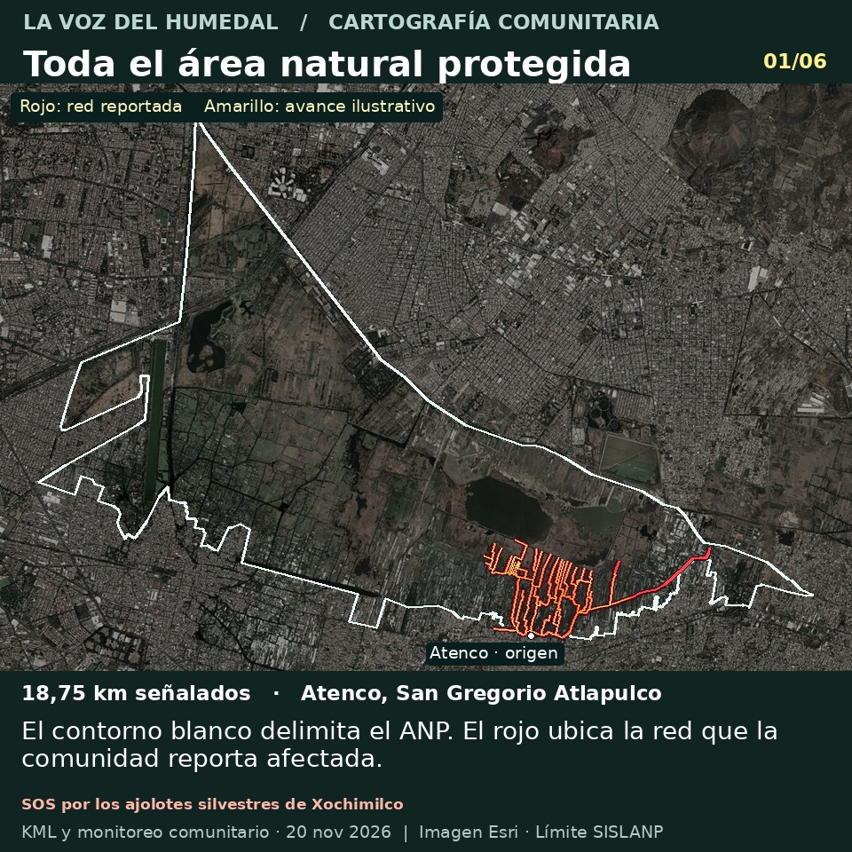
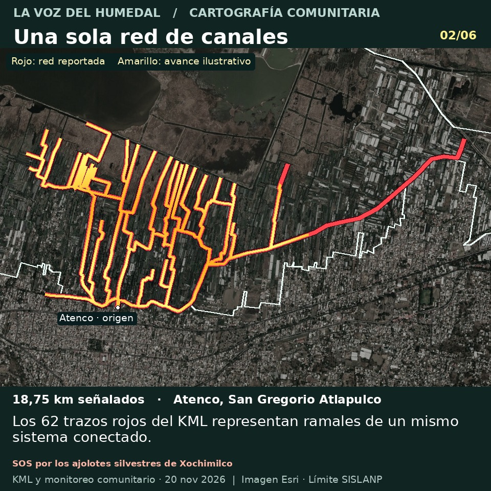
From the Atenco landing to the branches and the embankment, the community has identified 18.75 km of canals inside the protected area.

White outlines the protected area. Red marks the canals identified by the community. Yellow illustrates the reported spread from Atenco across the network. Flow speed has yet to be measured.

What proportion does this represent?

18.75 kmof canals reported
The 62 red lines originally totalled 23.41 km. Merging exact overlaps left 18.75 km of mapped canals, including the embankment.
7 of 7stations with a zero reading
All stations visited recorded a dissolved oxygen reading of zero, according to the community report of November 20, 2026.
9.2%of the historical canal length
The mapped network equals approximately 9.2% of the 203 km of connected canals described in the historical Ramsar information sheet.

Video evidence from November 20

Field videos without audio, recorded by Santuario Ajolote A.C. and CIMA A.C.

Video 1 · 20/11/2026
Video 2 · 20/11/2026
Video 3 · 20/11/2026
Video 4 · 20/11/2026
Video 5 · 20/11/2026
Video 6 · 20/11/2026
Video 7 · 20/11/2026
Video 8 · 20/11/2026

Readings from the November 20 survey (points 1 to 5)

O₂ · Dissolved oxygen

0

pH · pH

9

ALK · Alkalinity

MAX

Br · Bromine

MAX

NO₂ · Nitrites

MAX

NO₃ · Nitrates

MAX

MAX = top of the test-strip scale; it cannot show how much higher the real value is. The zero oxygen reading applies to the whole survey.

SOS

What if this water reaches the last axolotls of Xochimilco?

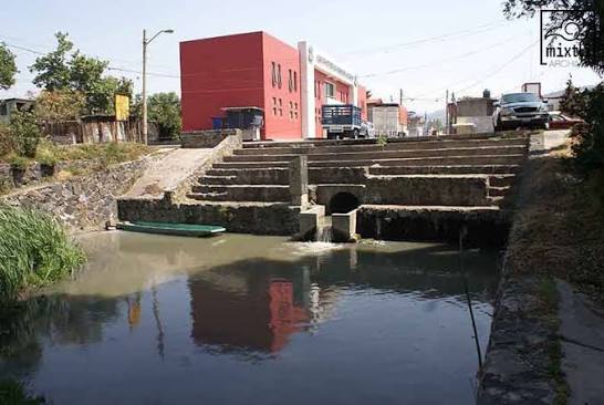
Atenco Canal — Overview
Atenco Canal — Overview · CIMA A.C.

First came the dead fish. Then, on October 30, an instrument read zero dissolved oxygen near the Atenco pier. Three weeks later, the Santuario Ajolote A.C. and CIMA A.C. team measured again, at different points, and got the same result. According to their field report, zero was repeated at every station visited.

This is the SOS of Atenco. If the episode persists or reaches one of the refuges that still sustain wild life, it could kill some of the last axolotls of Xochimilco. No record presented for this report documents a dead axolotl. The urgency lies in arriving in time to find out what is happening while protection is still possible.

THE OCTOBER SIGNAL

The water changed for two or three days at a time

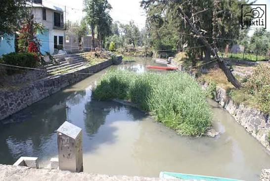
Dead Fish — Evidence of Ecological Impact
Dead Fish — Evidence of Ecological Impact · CIMA A.C.

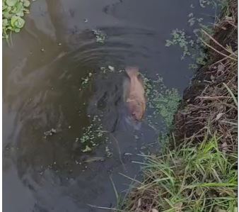
Between October 9 and 30, residents recorded dead fish that looked like adult tilapia and a coot. Water looked whitish, greenish or brown, with a smell of decay and sometimes sulfur. Signs vanished after two or three days and then returned, so an inspection after the water clears can miss what families saw.

On October 30, four samplings in the Atenco area recorded pH 9 and dissolved oxygen at zero; test strips reached the top of their scales. Without verifying units and method, converting them to exact concentrations would be false precision.

Extraordinary report of October 30 ↗

TWO YEARS OF MONITORING

What was already known before the fish were found

Atenco Canal — Urban Infrastructure
Atenco Canal — Urban Infrastructure · CIMA A.C.

Between September 2024 and September 2026 the community team held nine monitoring days across a four-station network. On November 20, the first five points showed the same readings: zero oxygen, pH 9, and alkalinity, bromine, nitrites and nitrates at the top of the scale, plus iron and cyanuric acid. Between points 5 and 6 there is a concrete place to return to with the chinampa farmers.

Monitoring data 2024–2026 ↗

THE WILD AXOLOTL

The encounter documented by CIMA A.C.

595 interviews · Read the original survey ↗

On July 17, 2026, CIMA A.C. filmed an individual among submerged branches in a restored canal in San Gregorio Atlapulco for about a minute without handling it. Observation 387789641 by cimaac reached research grade as Ambystoma mexicanum on iNaturalist.

As of November 20, it was the latest worldwide iNaturalist observation for this species when filtered for wild organisms and research grade and sorted by observation date. Other entries covering this encounter do not indicate additional animals.

CIMA’s original 2019–2023 survey included 595 interviews across three areas. It recorded two sightings in San Gregorio, in 2020 and 2021, and none in the other two surveyed areas. Its biotic integrity score was 6/25. Estimating population size requires accounting for the probability of detection.

Canals reported around Atenco

Combined length of reported canal branches

18.75 km

The November 20 community map totals 62 red lines. Seven stations mark discrete sampling sites. Yellow illustrates channel connections. The extent of the event requires measurements along each branch.

The canal network surveyed, with the seven monitoring stations of November 20 and the Cuacontle pier to the north.
Wider view: the corridor runs from the Atenco pier toward the branches of San Gregorio Atlapulco and San Luis Tlaxialtemalco.

Illustrative images of the survey: the canal network and the seven monitoring stations of November 20, marked by hand on the satellite photo. They are not a topographic survey.

Open the original project in Google Earth

Atenco · Xochimilco

Public environmental complaint about a possible unlawful discharge in Atenco

Complete your details and identify any firsthand observations. Paste the Spanish complaint into the official form or open an email and attach the reports, map and evidence. Keep your receipt or case number.

A la Procuraduría Federal de Protección al Ambiente Quien suscribe, [nombre, domicilio, teléfono y correo], presenta denuncia popular con fundamento en los artículos 189 y 190 de la LGEEPA por hechos ocurridos en el embarcadero de Atenco y sus canales, en San Gregorio Atlapulco, Xochimilco, Ciudad de México. Santuario Ajolote y CIMA A.C. documentaron nueve jornadas de monitoreo entre septiembre de 2024 y septiembre de 2026. En octubre se reportaron peces muertos y episodios de cambio de color y olor. El 30 de octubre el equipo registró pH 9 y una lectura de cero de oxígeno disuelto. El 20 de noviembre reportó lecturas de cero en siete estaciones. El mapa comunitario señala 18,75 km de ramales. La distribución de contaminantes, su origen y la causa de la mortandad requieren verificación. Solicito inspección urgente de las posibles descargas, identificación de sus operadores, permisos y jurisdicción del cuerpo receptor. Pido muestras simultáneas aguas arriba, en las salidas y aguas abajo, con instrumentos calibrados, cadena de custodia y análisis de laboratorio. Solicito evaluar medidas urgentes para proteger la fauna y los refugios. Una descarga ilícita en aguas de competencia federal que cause daño ambiental o riesgo de daño puede actualizar el artículo 416 del Código Penal Federal. Solicito que, de advertirse indicios de delito, se dé vista al Ministerio Público competente. Si algún aspecto corresponde a otra autoridad, solicito su remisión y que se me informe del trámite. Solicito acuse, folio y notificación al correo señalado. Hechos que observé personalmente y fecha: [completar, si corresponde]. Anexos: [enumerar los archivos efectivamente adjuntos]. Lugar, fecha y firma: [completar].

Legal annex

Zoning and discharges

The management plan distinguishes Protection (wetlands and wildlife refuges), Chinampa and Rainfed Agriculture, and Public Use. PAOT also maps an Ecological Restoration subzone. Rule 30(III) prohibits wastewater discharge across the protected area. Community concern centres on core habitat. Identifying affected stretches inside the formal Protection Zone requires an overlay with official zoning and field verification of flow.

Official source ↗

Mexico City

Local criminal code article 346(II) covers unlawful wastewater discharge causing harm to health or ecosystems or their elements. Conduct inside a city protected area can increase the penalty. Investigators must establish the discharge, responsible party, damage and causal link. Article 346 Bis requires intent, serious environmental harm and a statutory circumstance, including damage to an ecosystem inhabited by an endemic species. Mexico City exercises state-level jurisdiction here.

Official source ↗

Federal jurisdiction

Federal criminal code article 416 covers unlawful discharge, including ordering or authorising it, into federally regulated receiving environments where it causes environmental harm or risk. CONAGUA can establish jurisdiction and permit status. The federal prosecutor investigates federal offences. An open drain identifies infrastructure. Inspection and sampling establish its contents and destination.

Official source ↗

International wetland obligations

Xochimilco and San Gregorio form Ramsar Site 1363. Article 3.2 requires Mexico to learn of and promptly notify the Convention Secretariat of actual or likely changes in ecological character caused by pollution or other human intervention. This is a state obligation. Designation alone does not establish an international criminal offence.

Official source ↗

To resolve the case, identify the operator and receiving water, record the inspection and collect simultaneous samples at the outfall, upstream and downstream. Document time, flow, calibration and chain of custody to test the link with observed damage. PAOT zoning map ↗
Field notebook and supporting documents

In September and November 2024 the series reports positive E. coli screens at the three outside sites and negative screens inside the filters. Later blank cells are missing data. The compilation reverses the numbering of the two endpoints relative to the web index. Compare names and coordinates before pairing stations. The seven November 2026 points belong to a separate survey.

From the newspaper archive

02.12.2022 · El Heraldo de México

San Gregorio residents protested the Actopan collector works.

Read the story ↗

05.06.2024 · Publimetro

During a visit to San Luis and San Gregorio, a grower described irrigation water problems in Tlamelaca.

Read the story ↗

27.06.2024 · La Jornada

Farmers in San Gregorio described dry irrigation ditches and unfinished water supply works.

Read the story ↗

18.08.2024 · La Jornada

Residents documented sewage flooding a street in San Luis Tlaxialtemalco.

Read the story ↗

28.08.2024 · La Jornada

Growers described runoff toward the canals via Cuacontle. The source of the 2026 event requires a separate investigation.

Read the story ↗

24.10.2024 · La Razón

Xochimilco communities called for water infrastructure and access in interviews with the newspaper.

Read the story ↗

18.05.2025 · La Jornada

Michel Balam Traverse discussed the community survey. The story cites 565 interviews in 2020–2024. CIMA’s PDF gives 595 in 2019–2023. The two accounts are reported separately.

Read the story ↗

Where the information comes from

The October and November reconstruction comes from field reports by Santuario Ajolote A.C. and CIMA A.C. At press time there was no official ruling on the November 20 episode. No record documents a dead axolotl.

  • [1] La Jornada · Aguas negras en San Luis Tlaxialtemalco, agosto de 2024
  • [2] La Jornada · Reclamo por obras inconclusas, junio de 2024
  • [3] La Jornada · Zanjas secas en San Gregorio, febrero de 2025
  • [4] Publimetro · Recorrido con productores, junio de 2024
  • [5] PAOT · Expediente 2010-0201-SPA-124, San Luis Tlaxialtemalco
  • [6] El Heraldo de México · Protesta por el Colector Actopan, diciembre de 2022
  • [7] La Razón · Reclamos de abasto de los pueblos, octubre de 2024
  • [8] Gaceta Oficial · Programa de Manejo de los Ejidos de Xochimilco y San Gregorio

Monitoring data 2024–2026Extraordinary report of October 30